Streaming NEXRAD Level 2 Chunks from S3#
xradar can now ingest a list of NEXRAD Level 2 chunk byte objects directly, so you can stream real-time radar data from S3 without downloading full volume files first. This notebook demonstrates:
Listing and downloading chunk files from the
unidata-nexrad-level2-chunksbucketOpening a full volume assembled from all chunks
Handling partial volumes with
incomplete_sweep="drop"(default)Handling partial volumes with
incomplete_sweep="pad"Early streaming with just a few chunks
import warnings

import cmweather  # noqa: F401 -- registers colormaps
import fsspec
import matplotlib.pyplot as plt
import numpy as np

import xradar as xd
Background: NEXRAD chunk files on S3#
NOAA publishes NEXRAD Level 2 data to two public S3 buckets:
Bucket |
Content |
Latency |
|---|---|---|
|
Complete volume files |
Minutes after scan |
|
Real-time chunk files |
Seconds after scan |
Each radar volume is split into many small chunk files that arrive as the radar scans. A volume directory typically contains:
One S (start) chunk that includes the volume header
Many I (intermediate) chunks with sweep data
One E (end) chunk marking the volume boundary
For example:
KABR/903/KABR20250717_120038_V06_S  (start)
KABR/903/KABR20250717_120038_V06_I02  (intermediate)
KABR/903/KABR20250717_120038_V06_I03
...
KABR/903/KABR20250717_120038_V06_E   (end)
xradar accepts a list of chunk bytes (or file paths, or file-like objects)
directly via open_nexradlevel2_datatree(). The chunks are concatenated
internally, so you never need to assemble them manually.
Load chunk data#
chunk_paths = []

try:
    fs = fsspec.filesystem("s3", anon=True)
    volumes = sorted(fs.ls("unidata-nexrad-level2-chunks/KABR/"))
    if volumes:
        chunk_paths = sorted(fs.ls(volumes[-1]))
except Exception:
    pass

if chunk_paths:
    print(f"Using live S3 chunks: {len(chunk_paths)} files")
    for p in chunk_paths[:3]:
        print(f"  {p.split('/')[-1]}")
    print(f"  ... {chunk_paths[-1].split('/')[-1]}")
else:
    print("S3 bucket empty or unreachable, using open-radar-data fixture")
/home/docs/checkouts/readthedocs.org/user_builds/xradar/conda/stable/lib/python3.13/site-packages/fsspec/registry.py:301: UserWarning: Your installed version of s3fs is very old and known to cause
severe performance issues, see also https://github.com/dask/dask/issues/10276

To fix, you should specify a lower version bound on s3fs, or
update the current installation.

  warnings.warn(s3_msg)
Using live S3 chunks: 14 files
  20260421-121521-001-S
  20260421-121521-002-I
  20260421-121521-003-I
  ... 20260421-121521-014-E
Download / load chunk bytes#
if chunk_paths:
    all_bytes = [fs.open(p, "rb").read() for p in chunk_paths]
else:
    import tarfile
    from pathlib import Path

    from open_radar_data import DATASETS

    archive = DATASETS.fetch("nexrad_level2_chunks_KLOT.tar.gz")
    with tarfile.open(archive) as tar:
        tar.extractall("/tmp/nexrad_chunks", filter="data")
    chunk_files = sorted(Path("/tmp/nexrad_chunks/nexrad_chunks_KLOT").iterdir())
    all_bytes = [f.read_bytes() for f in chunk_files]

total_mb = sum(len(b) for b in all_bytes) / 1e6
print(f"Loaded {len(all_bytes)} chunks ({total_mb:.1f} MB total)")
Loaded 14 chunks (2.1 MB total)
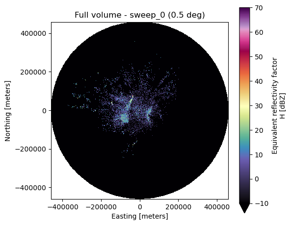
Full volume from all chunks#
When all chunks (S through E) are available, passing the list to
open_nexradlevel2_datatree produces the same result as opening a
complete volume file.
dtree = xd.io.open_nexradlevel2_datatree(all_bytes)
display(dtree)
/tmp/ipykernel_3954/601822868.py:1: UserWarning: Dropped 1 incomplete sweep(s): [2]. Use incomplete_sweep='pad' to include them with NaN-filled rays.
  dtree = xd.io.open_nexradlevel2_datatree(all_bytes)
<xarray.DataTree>
Group: /
│   Dimensions:              ()
│   Coordinates:
│       latitude             float64 8B 45.46
│       longitude            float64 8B -98.41
│       altitude             int64 8B 421
│   Data variables:
│       volume_number        int64 8B 0
│       platform_type        <U5 20B 'fixed'
│       instrument_type      <U5 20B 'radar'
│       time_coverage_start  <U20 80B '2026-04-21T12:15:21Z'
│       time_coverage_end    <U20 80B '2026-04-21T12:16:58Z'
│   Attributes: (12/25)
│       Conventions:                  None
│       instrument_name:              KABR
│       version:                      None
│       title:                        None
│       institution:                  None
│       references:                   None
│       ...                           ...
│       avset_enabled:                True
│       ebc_enabled:                  True
│       super_res_status:             2
│       rda_build_number:             2400
│       operational_mode:             4
│       actual_elevation_cuts:        3
├── Group: /sweep_0
│       Dimensions:            (azimuth: 720, range: 1832)
│       Coordinates:
│         * azimuth            (azimuth) float64 6kB 0.2444 0.7526 1.258 ... 359.3 359.8
│           elevation          (azimuth) float64 6kB 0.4395 0.4395 ... 0.4395 0.4395
│           time               (azimuth) datetime64[ns] 6kB ...
│           range              (range) float32 7kB 2.125e+03 2.375e+03 ... 4.599e+05
│       Data variables:
│           DBZH               (azimuth, range) float64 11MB ...
│           ZDR                (azimuth, range) float64 11MB ...
│           PHIDP              (azimuth, range) float64 11MB ...
│           RHOHV              (azimuth, range) float64 11MB ...
│           CCORH              (azimuth, range) float64 11MB ...
│           sweep_mode         <U20 80B 'azimuth_surveillance'
│           sweep_number       int64 8B 0
│           prt_mode           <U7 28B 'not_set'
│           follow_mode        <U7 28B 'not_set'
│           sweep_fixed_angle  float64 8B 0.4834
│       Attributes:
│           waveform_type:          contiguous_surveillance
│           channel_config:         sz2_phase_coding
│           super_resolution:       11
│           sails_cut:              False
│           sails_sequence_number:  0
│           mrle_cut:               False
│           mrle_sequence_number:   0
│           mpda_cut:               False
│           base_tilt_cut:          False
└── Group: /sweep_1
        Dimensions:            (azimuth: 718, range: 1192)
        Coordinates:
          * azimuth            (azimuth) float64 6kB 1.2 1.695 2.211 ... 359.2 359.7
            elevation          (azimuth) float64 6kB 0.4395 0.4395 ... 0.4395 0.4395
            time               (azimuth) datetime64[ns] 6kB ...
            range              (range) float32 5kB 2.125e+03 2.375e+03 ... 2.999e+05
        Data variables:
            DBZH               (azimuth, range) float64 7MB ...
            VRADH              (azimuth, range) float64 7MB ...
            WRADH              (azimuth, range) float64 7MB ...
            sweep_mode         <U20 80B 'azimuth_surveillance'
            sweep_number       int64 8B 1
            prt_mode           <U7 28B 'not_set'
            follow_mode        <U7 28B 'not_set'
            sweep_fixed_angle  float64 8B 0.4834
        Attributes:
            waveform_type:          contiguous_doppler
            channel_config:         sz2_phase_coding
            super_resolution:       7
            sails_cut:              False
            sails_sequence_number:  0
            mrle_cut:               False
            mrle_sequence_number:   0
            mpda_cut:               False
base_tilt_cut: Falseds = xd.georeference.get_x_y_z(dtree["sweep_0"].to_dataset(inherit="all_coords"))
fig, ax = plt.subplots(figsize=(6, 5))
ds.DBZH.plot(x="x", y="y", cmap="ChaseSpectral", vmin=-10, vmax=70, ax=ax)
ax.set_title(f"Full volume - sweep_0 ({ds.sweep_fixed_angle.values:.1f} deg)")
ax.set_aspect("equal")
fig.tight_layout()
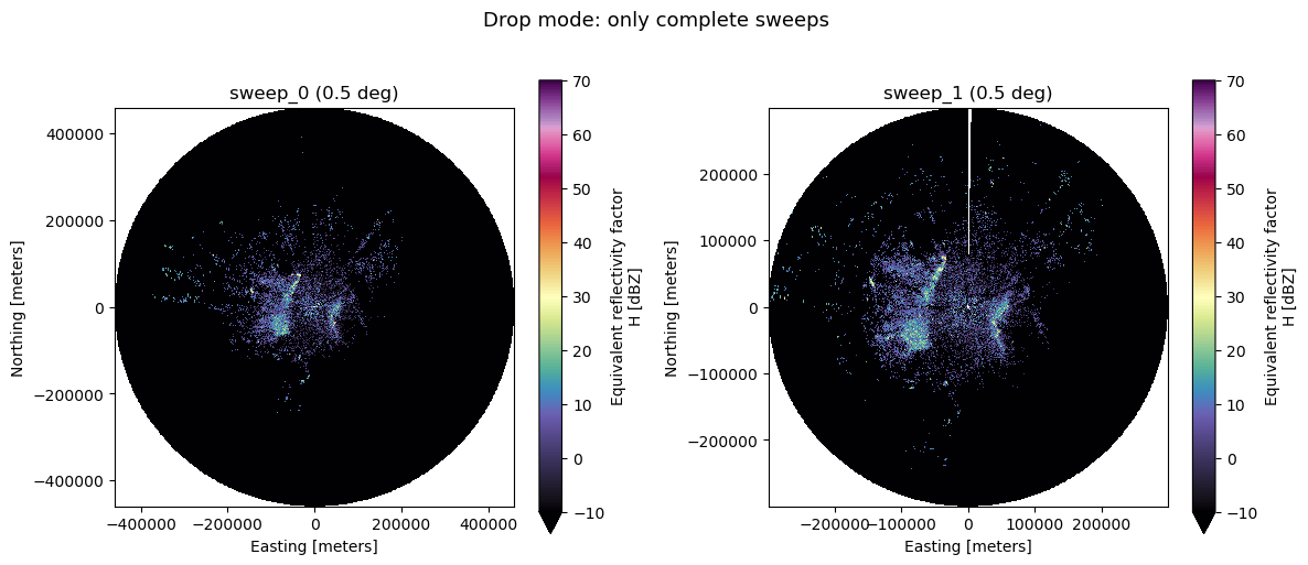
Partial volume – drop mode (default)#
When only some chunks have arrived, the last sweep is usually incomplete
(fewer rays than a full 360-degree rotation). By default,
incomplete_sweep="drop" excludes these partial sweeps and emits a warning.
This is the safest option for downstream processing that expects complete sweeps.
partial_chunks = all_bytes[:15]

with warnings.catch_warnings(record=True) as w:
    warnings.simplefilter("always")
    dtree_drop = xd.io.open_nexradlevel2_datatree(
        partial_chunks, incomplete_sweep="drop"
    )

# Show warnings
for warning in w:
    print(f"WARNING: {warning.message}")

sweep_groups = list(dtree_drop.match("sweep_*").keys())
print(f"\nSweeps kept: {sweep_groups}")
WARNING: Dropped 1 incomplete sweep(s): [2]. Use incomplete_sweep='pad' to include them with NaN-filled rays.

Sweeps kept: ['sweep_0', 'sweep_1']
if len(sweep_groups) >= 2:
    fig, axes = plt.subplots(1, 2, figsize=(12, 5))
    for ax, grp in zip(axes, sweep_groups[:2]):
        ds = xd.georeference.get_x_y_z(dtree_drop[grp].to_dataset(inherit="all_coords"))
        ds.DBZH.plot(x="x", y="y", cmap="ChaseSpectral", vmin=-10, vmax=70, ax=ax)
        ax.set_title(f"{grp} ({ds.sweep_fixed_angle.values:.1f} deg)")
        ax.set_aspect("equal")
    fig.suptitle("Drop mode: only complete sweeps", y=1.02, fontsize=13)
    fig.tight_layout()
elif len(sweep_groups) == 1:
    fig, ax = plt.subplots(figsize=(6, 5))
    ds = xd.georeference.get_x_y_z(
        dtree_drop[sweep_groups[0]].to_dataset(inherit="all_coords")
    )
    ds.DBZH.plot(x="x", y="y", cmap="ChaseSpectral", vmin=-10, vmax=70, ax=ax)
    ax.set_title(f"{sweep_groups[0]} ({ds.sweep_fixed_angle.values:.1f} deg)")
    ax.set_aspect("equal")
    fig.suptitle("Drop mode: only complete sweeps", y=1.02, fontsize=13)
    fig.tight_layout()
else:
    print("No complete sweeps in 15 chunks (all dropped).")
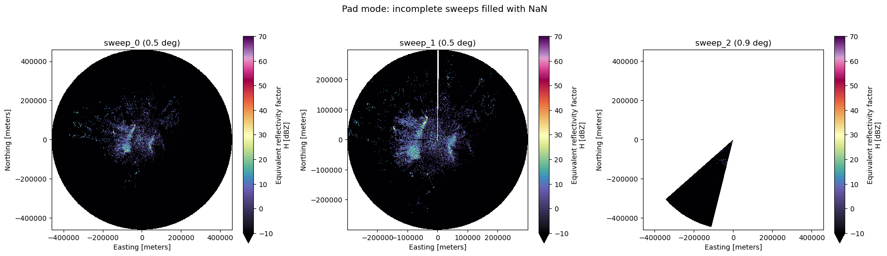
Partial volume – pad mode#
With incomplete_sweep="pad", incomplete sweeps are kept and reindexed
to a full azimuth grid. Missing rays are filled with NaN. The angular
resolution (0.5 or 1.0 degree) is auto-detected from the data.
This is useful for visualization and monitoring where you want to see all available data as soon as it arrives.
dtree_pad = xd.io.open_nexradlevel2_datatree(partial_chunks, incomplete_sweep="pad")

sweep_groups_pad = list(dtree_pad.match("sweep_*").keys())
print(f"Sweeps available (pad mode): {sweep_groups_pad}")

# Show NaN percentage in each sweep
for grp in sweep_groups_pad:
    ds = dtree_pad[grp].to_dataset()
    if "DBZH" in ds:
        nan_pct = np.isnan(ds.DBZH.values).mean() * 100
        print(f"  {grp}: azimuth size={ds.sizes['azimuth']}, DBZH NaN={nan_pct:.1f}%")
Sweeps available (pad mode): ['sweep_0', 'sweep_1', 'sweep_2']
  sweep_0: azimuth size=720, DBZH NaN=0.0%
  sweep_1: azimuth size=718, DBZH NaN=0.0%
  sweep_2: azimuth size=720, DBZH NaN=90.4%
n_sweeps = len(sweep_groups_pad)
fig, axes = plt.subplots(1, n_sweeps, figsize=(6 * n_sweeps, 5))
if n_sweeps == 1:
    axes = [axes]

for ax, grp in zip(axes, sweep_groups_pad):
    ds = xd.georeference.get_x_y_z(dtree_pad[grp].to_dataset(inherit="all_coords"))
    ds.DBZH.plot(x="x", y="y", cmap="ChaseSpectral", vmin=-10, vmax=70, ax=ax)
    ax.set_title(f"{grp} ({ds.sweep_fixed_angle.values:.1f} deg)")
    ax.set_aspect("equal")

fig.suptitle("Pad mode: incomplete sweeps filled with NaN", y=1.02, fontsize=13)
fig.tight_layout()
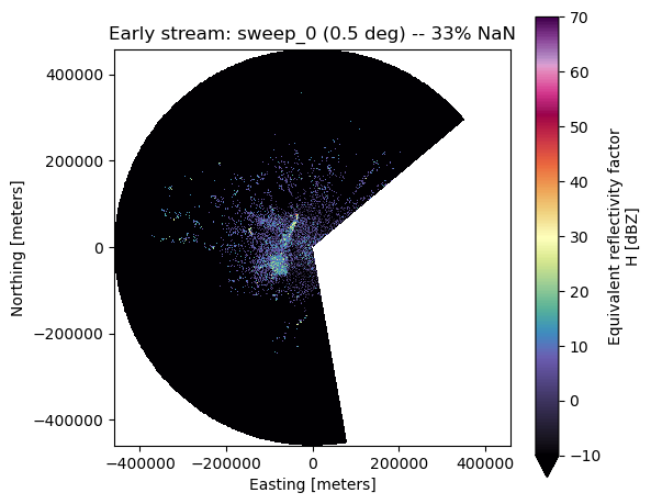
Early streaming – few chunks#
Even with only 5 chunks (before the first sweep completes), pad mode shows the partial data that has arrived. The NaN wedge makes it clear which azimuths are still missing.
early_chunks = all_bytes[:5]

dtree_early = xd.io.open_nexradlevel2_datatree(early_chunks, incomplete_sweep="pad")

sweep_groups_early = list(dtree_early.match("sweep_*").keys())
print(f"Sweeps from 5 chunks: {sweep_groups_early}")

if sweep_groups_early:
    ds = xd.georeference.get_x_y_z(
        dtree_early[sweep_groups_early[0]].to_dataset(inherit="all_coords")
    )

    nan_pct = np.isnan(ds.DBZH.values).mean() * 100
    print(f"DBZH NaN percentage: {nan_pct:.1f}%")

    fig, ax = plt.subplots(figsize=(6, 5))
    ds.DBZH.plot(x="x", y="y", cmap="ChaseSpectral", vmin=-10, vmax=70, ax=ax)
    ax.set_title(
        f"Early stream: {sweep_groups_early[0]} "
        f"({ds.sweep_fixed_angle.values:.1f} deg) -- {nan_pct:.0f}% NaN"
    )
    ax.set_aspect("equal")
    fig.tight_layout()
else:
    print("No sweeps found in 5 chunks.")
/home/docs/checkouts/readthedocs.org/user_builds/xradar/conda/stable/lib/python3.13/site-packages/xradar/util.py:466: UserWarning: Rays might miss on beginning and/or end of sweep. `a1gate` information is needed to fully recover. We'll assume sweep start at first valid ray.
  warnings.warn(
Sweeps from 5 chunks: ['sweep_0']
DBZH NaN percentage: 33.3%
Summary#
Scenario |
|
Behavior |
|---|---|---|
Full volume (all chunks) |
|
All sweeps present, no difference |
Partial volume |
|
Incomplete sweeps excluded, warning emitted |
Partial volume |
|
Incomplete sweeps kept, missing rays filled with NaN |
Early stream (few chunks) |
|
Single partial sweep visible with NaN wedge |
Note: Single-file, bytes, and file-like inputs continue to work exactly as
before. The list input and incomplete_sweep parameter are additive features.