Reproject Radar Coordinates#
This notebook demonstrates the target_crs option now exposed on
.xradar.georeference() for xarray.Dataset and xarray.DataTree.
It lets you reproject radar x, y coordinates from the radar-native
Azimuthal Equidistant (AEQD) projection into any pyproj-compatible CRS
in a single accessor call:
radar = radar.xradar.georeference(target_crs=4326)
Imports#
import cartopy.crs as ccrs
import cmweather  # noqa
import matplotlib.pyplot as plt
import pyproj
from open_radar_data import DATASETS

import xradar as xd
Read a sample radar file#
filename = DATASETS.fetch("cfrad.20080604_002217_000_SPOL_v36_SUR.nc")
radar = xd.io.open_cfradial1_datatree(filename, first_dim="auto")
radar
<xarray.DataTree>
Group: /
│   Dimensions:              (sweep: 9)
│   Coordinates:
│       latitude             float64 8B ...
│       longitude            float64 8B ...
│       altitude             float64 8B ...
│   Dimensions without coordinates: sweep
│   Data variables:
│       volume_number        int32 4B ...
│       platform_type        |S32 32B ...
│       primary_axis         |S32 32B ...
│       status_str           |S1 1B ...
│       instrument_type      |S32 32B ...
│       time_coverage_start  |S32 32B ...
│       time_coverage_end    |S32 32B ...
│       sweep_group_name     (sweep) <U7 252B 'sweep_0' 'sweep_1' ... 'sweep_8'
│       sweep_fixed_angle    (sweep) float32 36B ...
│   Attributes: (12/13)
│       Conventions:         CF/Radial instrument_parameters radar_parameters rad...
│       version:             1.2
│       title:               TIMREX
│       institution:
│       references:
│       source:
│       ...                  ...
│       comment:
│       instrument_name:     SPOLRVP8
│       site_name:
│       scan_name:
│       scan_id:             0
│       platform_is_mobile:  false
├── Group: /sweep_0
│       Dimensions:                    (azimuth: 483, range: 996)
│       Coordinates:
│         * azimuth                    (azimuth) float32 2kB 0.0 0.75 ... 358.5 359.2
│           elevation                  (azimuth) float32 2kB ...
│           time                       (azimuth) datetime64[ns] 4kB 2008-06-04T00:15:...
│         * range                      (range) float32 4kB 150.0 300.0 ... 1.494e+05
│       Data variables: (12/18)
│           sweep_number               int32 4B ...
│           sweep_mode                 <U20 80B 'azimuth_surveillance'
│           prt_mode                   |S32 32B ...
│           follow_mode                |S32 32B ...
│           sweep_fixed_angle          float32 4B ...
│           pulse_width                (azimuth) float32 2kB ...
│           ...                         ...
│           r_calib_index              (azimuth) int8 483B ...
│           measured_transmit_power_h  (azimuth) float32 2kB ...
│           measured_transmit_power_v  (azimuth) float32 2kB ...
│           scan_rate                  (azimuth) float32 2kB ...
│           DBZ                        (azimuth, range) float32 2MB ...
│           VR                         (azimuth, range) float32 2MB ...
├── Group: /sweep_1
│       Dimensions:                    (azimuth: 483, range: 996)
│       Coordinates:
│         * azimuth                    (azimuth) float32 2kB 0.0 0.75 ... 358.5 359.2
│           elevation                  (azimuth) float32 2kB ...
│           time                       (azimuth) datetime64[ns] 4kB 2008-06-04T00:16:...
│         * range                      (range) float32 4kB 150.0 300.0 ... 1.494e+05
│       Data variables: (12/18)
│           sweep_number               int32 4B ...
│           sweep_mode                 <U20 80B 'azimuth_surveillance'
│           prt_mode                   |S32 32B ...
│           follow_mode                |S32 32B ...
│           sweep_fixed_angle          float32 4B ...
│           pulse_width                (azimuth) float32 2kB ...
│           ...                         ...
│           r_calib_index              (azimuth) int8 483B ...
│           measured_transmit_power_h  (azimuth) float32 2kB ...
│           measured_transmit_power_v  (azimuth) float32 2kB ...
│           scan_rate                  (azimuth) float32 2kB ...
│           DBZ                        (azimuth, range) float32 2MB ...
│           VR                         (azimuth, range) float32 2MB ...
├── Group: /sweep_2
│       Dimensions:                    (azimuth: 482, range: 996)
│       Coordinates:
│         * azimuth                    (azimuth) float32 2kB 0.0 0.75 ... 358.5 359.2
│           elevation                  (azimuth) float32 2kB ...
│           time                       (azimuth) datetime64[ns] 4kB 2008-06-04T00:17:...
│         * range                      (range) float32 4kB 150.0 300.0 ... 1.494e+05
│       Data variables: (12/18)
│           sweep_number               int32 4B ...
│           sweep_mode                 <U20 80B 'azimuth_surveillance'
│           prt_mode                   |S32 32B ...
│           follow_mode                |S32 32B ...
│           sweep_fixed_angle          float32 4B ...
│           pulse_width                (azimuth) float32 2kB ...
│           ...                         ...
│           r_calib_index              (azimuth) int8 482B ...
│           measured_transmit_power_h  (azimuth) float32 2kB ...
│           measured_transmit_power_v  (azimuth) float32 2kB ...
│           scan_rate                  (azimuth) float32 2kB ...
│           DBZ                        (azimuth, range) float32 2MB ...
│           VR                         (azimuth, range) float32 2MB ...
├── Group: /sweep_3
│       Dimensions:                    (azimuth: 483, range: 996)
│       Coordinates:
│         * azimuth                    (azimuth) float32 2kB 0.0 0.75 ... 358.5 359.2
│           elevation                  (azimuth) float32 2kB ...
│           time                       (azimuth) datetime64[ns] 4kB 2008-06-04T00:17:...
│         * range                      (range) float32 4kB 150.0 300.0 ... 1.494e+05
│       Data variables: (12/18)
│           sweep_number               int32 4B ...
│           sweep_mode                 <U20 80B 'azimuth_surveillance'
│           prt_mode                   |S32 32B ...
│           follow_mode                |S32 32B ...
│           sweep_fixed_angle          float32 4B ...
│           pulse_width                (azimuth) float32 2kB ...
│           ...                         ...
│           r_calib_index              (azimuth) int8 483B ...
│           measured_transmit_power_h  (azimuth) float32 2kB ...
│           measured_transmit_power_v  (azimuth) float32 2kB ...
│           scan_rate                  (azimuth) float32 2kB ...
│           DBZ                        (azimuth, range) float32 2MB ...
│           VR                         (azimuth, range) float32 2MB ...
├── Group: /sweep_4
│       Dimensions:                    (azimuth: 481, range: 996)
│       Coordinates:
│         * azimuth                    (azimuth) float32 2kB 0.0 0.75 ... 358.5 359.2
│           elevation                  (azimuth) float32 2kB ...
│           time                       (azimuth) datetime64[ns] 4kB 2008-06-04T00:18:...
│         * range                      (range) float32 4kB 150.0 300.0 ... 1.494e+05
│       Data variables: (12/18)
│           sweep_number               int32 4B ...
│           sweep_mode                 <U20 80B 'azimuth_surveillance'
│           prt_mode                   |S32 32B ...
│           follow_mode                |S32 32B ...
│           sweep_fixed_angle          float32 4B ...
│           pulse_width                (azimuth) float32 2kB ...
│           ...                         ...
│           r_calib_index              (azimuth) int8 481B ...
│           measured_transmit_power_h  (azimuth) float32 2kB ...
│           measured_transmit_power_v  (azimuth) float32 2kB ...
│           scan_rate                  (azimuth) float32 2kB ...
│           DBZ                        (azimuth, range) float32 2MB ...
│           VR                         (azimuth, range) float32 2MB ...
├── Group: /sweep_5
│       Dimensions:                    (azimuth: 482, range: 996)
│       Coordinates:
│         * azimuth                    (azimuth) float32 2kB 0.0 0.75 ... 358.5 359.2
│           elevation                  (azimuth) float32 2kB ...
│           time                       (azimuth) datetime64[ns] 4kB 2008-06-04T00:19:...
│         * range                      (range) float32 4kB 150.0 300.0 ... 1.494e+05
│       Data variables: (12/18)
│           sweep_number               int32 4B ...
│           sweep_mode                 <U20 80B 'azimuth_surveillance'
│           prt_mode                   |S32 32B ...
│           follow_mode                |S32 32B ...
│           sweep_fixed_angle          float32 4B ...
│           pulse_width                (azimuth) float32 2kB ...
│           ...                         ...
│           r_calib_index              (azimuth) int8 482B ...
│           measured_transmit_power_h  (azimuth) float32 2kB ...
│           measured_transmit_power_v  (azimuth) float32 2kB ...
│           scan_rate                  (azimuth) float32 2kB ...
│           DBZ                        (azimuth, range) float32 2MB ...
│           VR                         (azimuth, range) float32 2MB ...
├── Group: /sweep_6
│       Dimensions:                    (azimuth: 482, range: 996)
│       Coordinates:
│         * azimuth                    (azimuth) float32 2kB 0.0 0.75 ... 358.5 359.2
│           elevation                  (azimuth) float32 2kB ...
│           time                       (azimuth) datetime64[ns] 4kB 2008-06-04T00:20:...
│         * range                      (range) float32 4kB 150.0 300.0 ... 1.494e+05
│       Data variables: (12/18)
│           sweep_number               int32 4B ...
│           sweep_mode                 <U20 80B 'azimuth_surveillance'
│           prt_mode                   |S32 32B ...
│           follow_mode                |S32 32B ...
│           sweep_fixed_angle          float32 4B ...
│           pulse_width                (azimuth) float32 2kB ...
│           ...                         ...
│           r_calib_index              (azimuth) int8 482B ...
│           measured_transmit_power_h  (azimuth) float32 2kB ...
│           measured_transmit_power_v  (azimuth) float32 2kB ...
│           scan_rate                  (azimuth) float32 2kB ...
│           DBZ                        (azimuth, range) float32 2MB ...
│           VR                         (azimuth, range) float32 2MB ...
├── Group: /sweep_7
│       Dimensions:                    (azimuth: 484, range: 996)
│       Coordinates:
│         * azimuth                    (azimuth) float32 2kB 0.0 0.75 ... 358.5 359.2
│           elevation                  (azimuth) float32 2kB ...
│           time                       (azimuth) datetime64[ns] 4kB 2008-06-04T00:21:...
│         * range                      (range) float32 4kB 150.0 300.0 ... 1.494e+05
│       Data variables: (12/18)
│           sweep_number               int32 4B ...
│           sweep_mode                 <U20 80B 'azimuth_surveillance'
│           prt_mode                   |S32 32B ...
│           follow_mode                |S32 32B ...
│           sweep_fixed_angle          float32 4B ...
│           pulse_width                (azimuth) float32 2kB ...
│           ...                         ...
│           r_calib_index              (azimuth) int8 484B ...
│           measured_transmit_power_h  (azimuth) float32 2kB ...
│           measured_transmit_power_v  (azimuth) float32 2kB ...
│           scan_rate                  (azimuth) float32 2kB ...
│           DBZ                        (azimuth, range) float32 2MB ...
│           VR                         (azimuth, range) float32 2MB ...
└── Group: /sweep_8
        Dimensions:                    (azimuth: 483, range: 996)
        Coordinates:
          * azimuth                    (azimuth) float32 2kB 0.0 0.75 ... 358.5 359.2
            elevation                  (azimuth) float32 2kB ...
            time                       (azimuth) datetime64[ns] 4kB 2008-06-04T00:21:...
          * range                      (range) float32 4kB 150.0 300.0 ... 1.494e+05
        Data variables: (12/18)
            sweep_number               int32 4B ...
            sweep_mode                 <U20 80B 'azimuth_surveillance'
            prt_mode                   |S32 32B ...
            follow_mode                |S32 32B ...
            sweep_fixed_angle          float32 4B ...
            pulse_width                (azimuth) float32 2kB ...
            ...                         ...
            r_calib_index              (azimuth) int8 483B ...
            measured_transmit_power_h  (azimuth) float32 2kB ...
            measured_transmit_power_v  (azimuth) float32 2kB ...
            scan_rate                  (azimuth) float32 2kB ...
            DBZ                        (azimuth, range) float32 2MB ...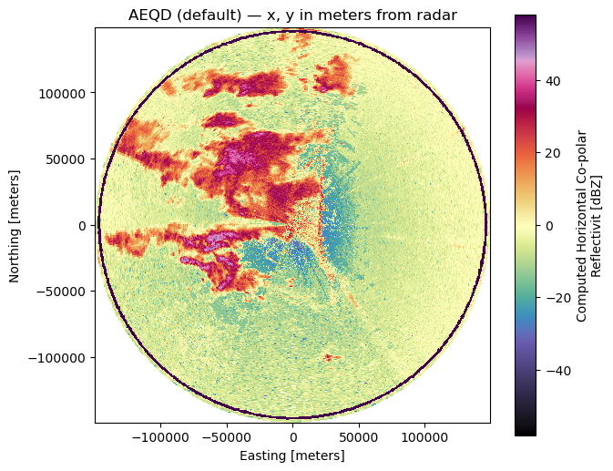
VR (azimuth, range) float32 2MB ...1. Default georeferencing (AEQD, meters)#
Without target_crs, the accessor adds x, y, z in the
radar-native AEQD projection (distances in meters from the radar site).
radar_aeqd = radar.xradar.georeference()
sweep = radar_aeqd["sweep_0"].to_dataset(inherit="all_coords")
crs = sweep.xradar.get_crs()
print("projection:", crs.coordinate_operation.method_name if crs.coordinate_operation else crs.name)
print("is_projected / is_geographic:", crs.is_projected, "/", crs.is_geographic)
print("x units:", sweep.x.attrs.get("units"))
print("x range:", float(sweep.x.min()), float(sweep.x.max()))
projection: Azimuthal Equidistant
is_projected / is_geographic: True / False
x units: meters
x range: -149353.7199056801 149354.1123565658
fig, ax = plt.subplots(figsize=(7, 6))
radar_aeqd["sweep_0"]["DBZ"].plot(x="x", y="y", cmap="ChaseSpectral", ax=ax)
ax.set_title("AEQD (default) — x, y in meters from radar")
ax.set_aspect("equal")
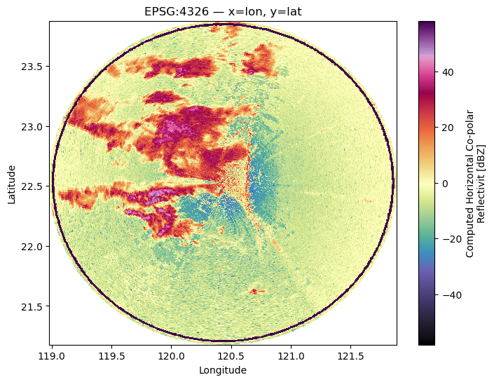
2. Reproject to geographic lon/lat (EPSG:4326)#
Pass target_crs=4326 to get x as longitude and y as latitude.
Attributes are updated automatically (standard_name, units).
radar_geo = radar.xradar.georeference(target_crs=4326)
sweep = radar_geo["sweep_0"].to_dataset(inherit="all_coords")
crs = sweep.xradar.get_crs()
print("CRS name:", crs.name, "| EPSG:", crs.to_epsg())
print("x attrs:", dict(sweep.x.attrs))
print("y attrs:", dict(sweep.y.attrs))
CRS name: WGS 84 | EPSG: 4326
x attrs: {'standard_name': 'longitude', 'long_name': 'Geographic Longitude', 'units': 'degrees_east', 'axis': 'X'}
y attrs: {'standard_name': 'latitude', 'long_name': 'Geographic Latitude', 'units': 'degrees_north', 'axis': 'Y'}
fig, ax = plt.subplots(figsize=(8, 6))
radar_geo["sweep_0"]["DBZ"].plot(x="x", y="y", cmap="ChaseSpectral", ax=ax)
ax.set_xlabel("Longitude")
ax.set_ylabel("Latitude")
ax.set_title("EPSG:4326 — x=lon, y=lat")
Text(0.5, 1.0, 'EPSG:4326 — x=lon, y=lat')
3. Reproject to a projected CRS (UTM, Web Mercator)#
Any pyproj-compatible CRS input works: EPSG code, WKT string, or a
pyproj.CRS instance.
# Web Mercator (meters)
radar_wm = radar.xradar.georeference(target_crs="EPSG:3857")
sweep_wm = radar_wm["sweep_0"].to_dataset(inherit="all_coords")
crs = sweep_wm.xradar.get_crs()
print("CRS:", crs.name, "| EPSG:", crs.to_epsg())
CRS: WGS 84 / Pseudo-Mercator | EPSG: 3857
utm_crs = pyproj.CRS("EPSG:32633")  # UTM zone 33N (tweak for your radar site)
radar_utm = radar.xradar.georeference(target_crs=utm_crs)
sweep_utm = radar_utm["sweep_0"].to_dataset(inherit="all_coords")
crs = sweep_utm.xradar.get_crs()
print("CRS:", crs.name, "| EPSG:", crs.to_epsg())
CRS: WGS 84 / UTM zone 33N | EPSG: 32633
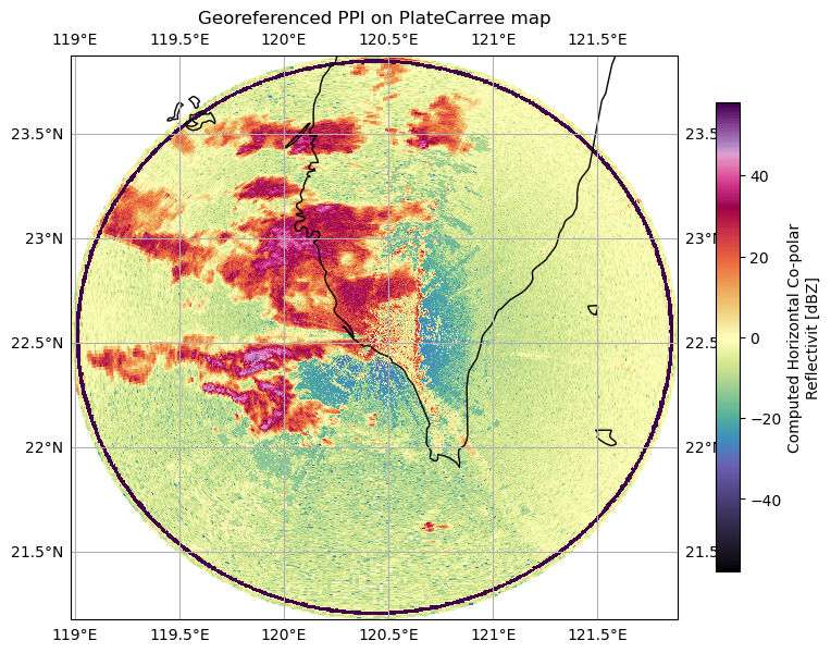
4. Plot on a cartopy map#
Once data is in a known CRS, hand it off to cartopy for map plotting.
radar_geo = radar.xradar.georeference(target_crs=4326)

fig = plt.figure(figsize=(9, 8))
ax = fig.add_subplot(111, projection=ccrs.PlateCarree())
radar_geo["sweep_0"]["DBZ"].plot(
    x="x",
    y="y",
    cmap="ChaseSpectral",
    transform=ccrs.PlateCarree(),
    ax=ax,
    cbar_kwargs=dict(pad=0.05, shrink=0.7),
)
ax.coastlines()
ax.gridlines(draw_labels=True)
ax.set_title("Georeferenced PPI on PlateCarree map")
Text(0.5, 1.0, 'Georeferenced PPI on PlateCarree map')
/home/docs/checkouts/readthedocs.org/user_builds/xradar/conda/latest/lib/python3.13/site-packages/cartopy/io/__init__.py:242: DownloadWarning: Downloading: https://naturalearth.s3.amazonaws.com/10m_physical/ne_10m_coastline.zip
  warnings.warn(f'Downloading: {url}', DownloadWarning)
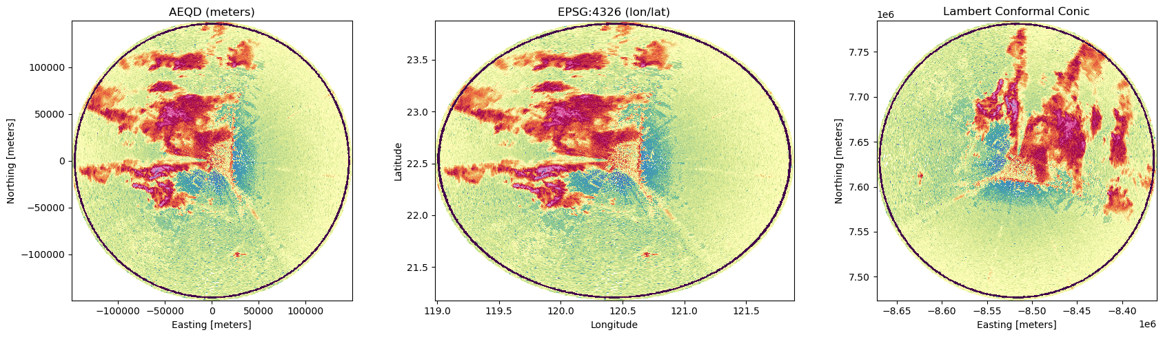
5. Side-by-side comparison of projections#
Compare the same sweep in AEQD (meters), geographic (lon/lat), and Lambert Conformal Conic — a projection commonly used for mid-latitude weather maps.
fig, axes = plt.subplots(1, 3, figsize=(18, 5))

# AEQD (default)
radar_aeqd = radar.xradar.georeference()
radar_aeqd["sweep_0"]["DBZ"].plot(
    x="x", y="y", cmap="ChaseSpectral", ax=axes[0], add_colorbar=False,
)
axes[0].set_title("AEQD (meters)")
axes[0].set_aspect("equal")

# EPSG:4326 (lon/lat)
radar_geo = radar.xradar.georeference(target_crs=4326)
radar_geo["sweep_0"]["DBZ"].plot(
    x="x", y="y", cmap="ChaseSpectral", ax=axes[1], add_colorbar=False,
)
axes[1].set_title("EPSG:4326 (lon/lat)")
axes[1].set_xlabel("Longitude")
axes[1].set_ylabel("Latitude")

# Lambert Conformal Conic
lcc_crs = pyproj.CRS.from_proj4(
    "+proj=lcc +lat_1=30 +lat_2=60 +lat_0=39.5 +lon_0=-105 +datum=WGS84"
)
radar_lcc = radar.xradar.georeference(target_crs=lcc_crs)
radar_lcc["sweep_0"]["DBZ"].plot(
    x="x", y="y", cmap="ChaseSpectral", ax=axes[2], add_colorbar=False,
)
axes[2].set_title("Lambert Conformal Conic")
axes[2].set_aspect("equal")

fig.tight_layout()
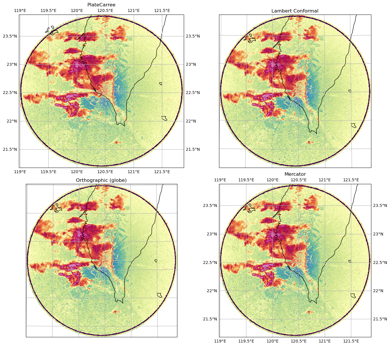
6. Radar data on different map projections#
The same georeferenced radar data rendered on four different cartopy map projections — coastlines and gridlines make the projection distortion visible.
import cartopy.feature as cfeature

radar_geo = radar.xradar.georeference(target_crs=4326)
lon0 = float(radar_geo.ds.coords["longitude"].values)
lat0 = float(radar_geo.ds.coords["latitude"].values)

projections = [
    ("PlateCarree", ccrs.PlateCarree()),
    ("Lambert Conformal", ccrs.LambertConformal(
        central_longitude=lon0, central_latitude=lat0,
    )),
    ("Orthographic (globe)", ccrs.Orthographic(
        central_longitude=lon0, central_latitude=lat0,
    )),
    ("Mercator", ccrs.Mercator(central_longitude=lon0)),
]

fig = plt.figure(figsize=(14, 12))

for i, (name, proj) in enumerate(projections, 1):
    ax = fig.add_subplot(2, 2, i, projection=proj)
    radar_geo["sweep_0"]["DBZ"].plot(
        x="x", y="y", cmap="ChaseSpectral",
        transform=ccrs.PlateCarree(), ax=ax,
        add_colorbar=False,
    )
    ax.coastlines()
    ax.add_feature(cfeature.BORDERS, linewidth=0.5)
    ax.gridlines(draw_labels=isinstance(proj, (ccrs.PlateCarree, ccrs.Mercator)))
    ax.set_title(name)

fig.tight_layout()
/home/docs/checkouts/readthedocs.org/user_builds/xradar/conda/latest/lib/python3.13/site-packages/cartopy/io/__init__.py:242: DownloadWarning: Downloading: https://naturalearth.s3.amazonaws.com/10m_cultural/ne_10m_admin_0_boundary_lines_land.zip
  warnings.warn(f'Downloading: {url}', DownloadWarning)
7. Works on a single Dataset too#
The accessor is available on Dataset and DataArray as well, not just
DataTree.
ds = radar["sweep_0"].to_dataset(inherit="all_coords")
ds_geo = ds.xradar.georeference(target_crs=4326)
ds_geo[["DBZ"]]
<xarray.Dataset> Size: 13MB
Dimensions:    (azimuth: 483, range: 996)
Coordinates:
  * azimuth    (azimuth) float32 2kB 0.0 0.75 1.5 2.25 ... 357.8 358.5 359.2
    elevation  (azimuth) float32 2kB 0.5164 0.5219 0.5164 ... 0.5219 0.5219
    time       (azimuth) datetime64[ns] 4kB 2008-06-04T00:15:34 ... 2008-06-0...
  * range      (range) float32 4kB 150.0 300.0 450.0 ... 1.492e+05 1.494e+05
    x          (azimuth, range) float64 4MB 120.4 120.4 120.4 ... 120.4 120.4
    y          (azimuth, range) float64 4MB 22.53 22.53 22.53 ... 23.87 23.88
    z          (azimuth, range) float64 4MB 46.35 47.71 ... 2.714e+03 2.718e+03
    latitude   float64 8B 22.53
    longitude  float64 8B 120.4
    altitude   float64 8B 45.0
    crs_wkt    int64 8B 0
Data variables:
DBZ (azimuth, range) float32 2MB ...Summary#
target_crsaccepts anythingpyproj.CRS(...)accepts: int EPSG codes,"EPSG:xxxx"strings, WKT, orpyproj.CRSinstances.The
spatial_ref/crs_wktcoordinate is updated to reflect the target CRS —sweep.xradar.get_crs()will return it.Currently only
xandyare reprojected;zstays as AEQD altitude above the radar site.If you want separate
lon/lat/altcoordinates (without overwritingx, y), see the Assign_GeoCoords notebook.